
Love and Power in the Land of the Sixth Dalai Lama
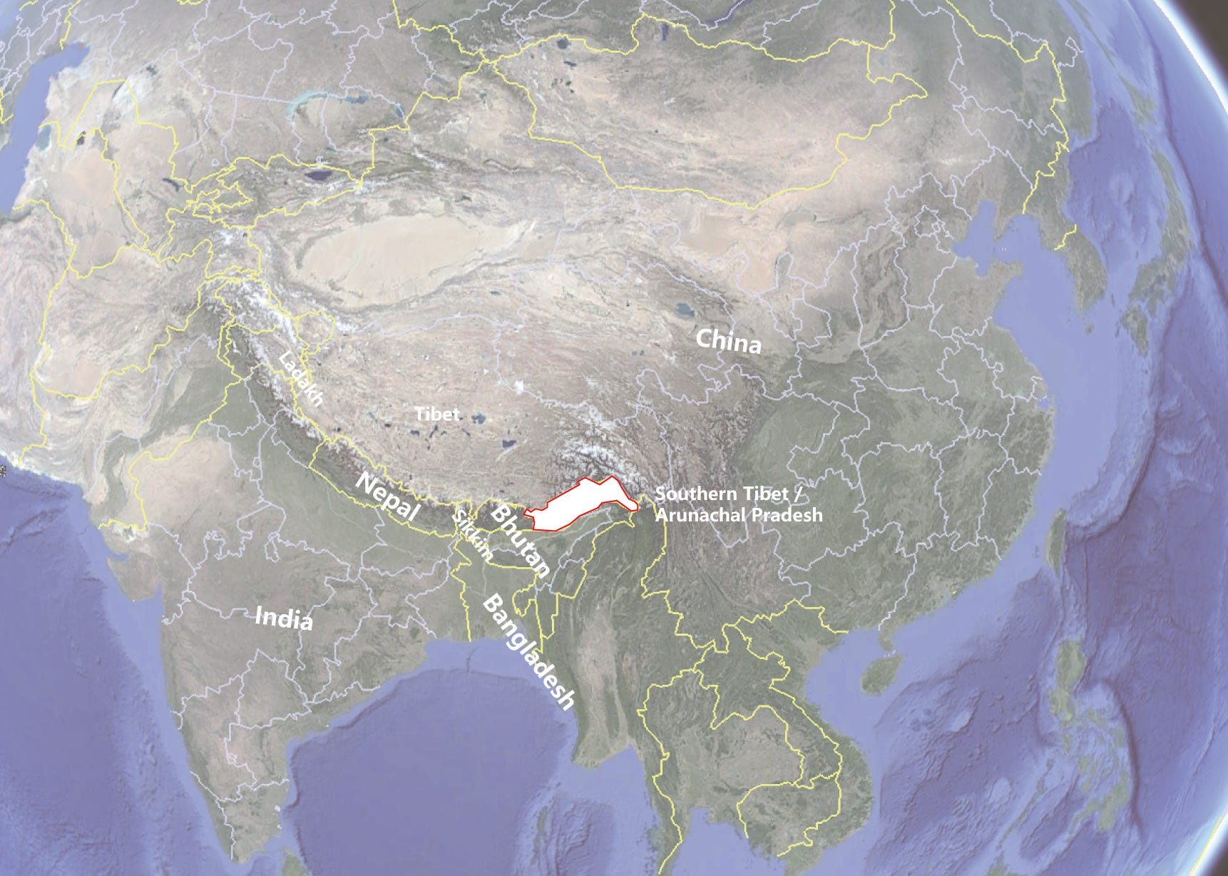
Inside the Southern Tibet / Arunachal Pradesh Dispute

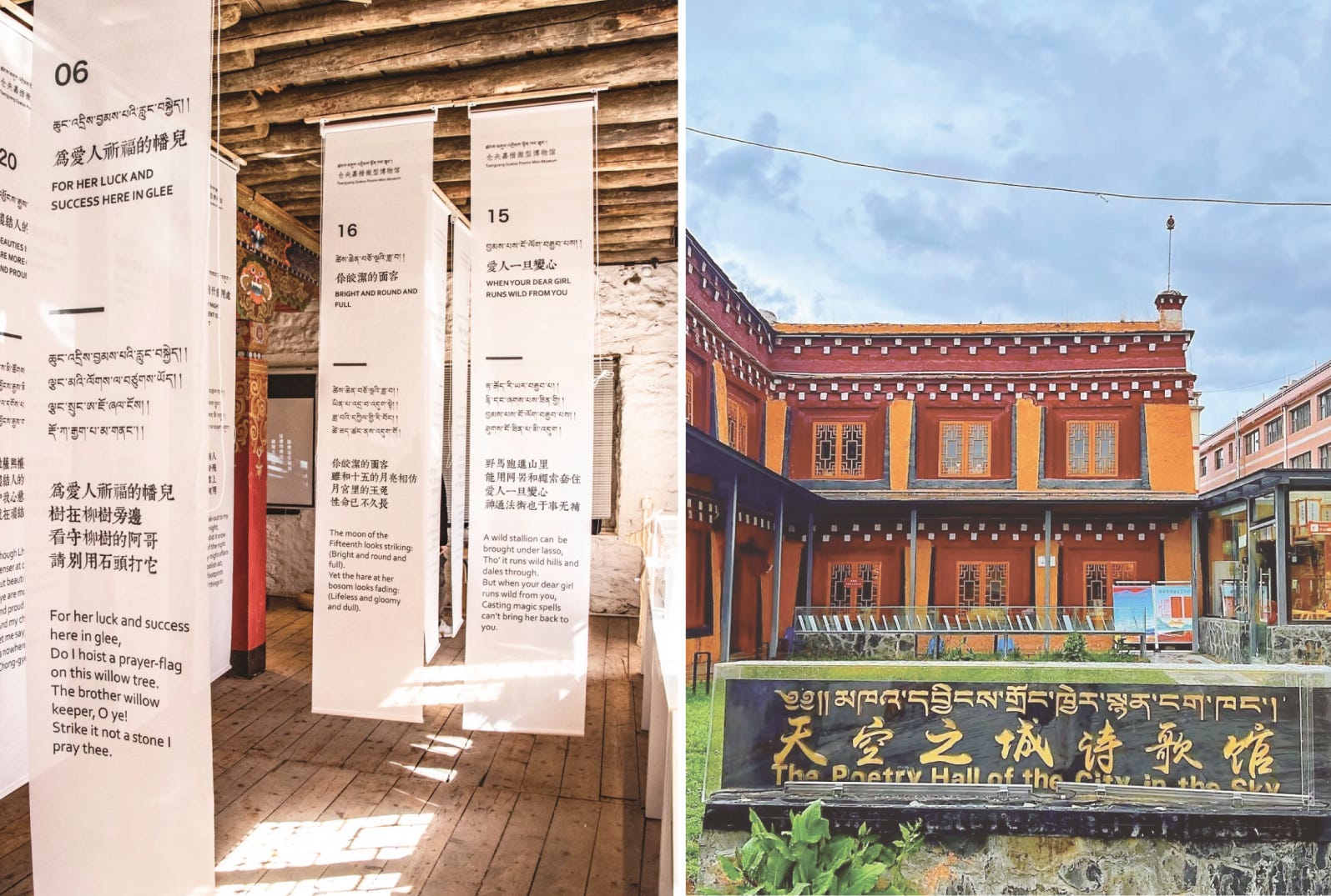
In a Beijing bookstore in the 2010s, a collection of soulful Tibetan love poems topped the bestseller charts. The verses are attributed to Tsangyang Gyatso (仓央嘉错) – the Sixth Dalai Lama – whose romantic lyrics, filled with yearning and spiritual paradox, struck a chord with Chinese readers centuries after his time. Ironically, Tsangyang Gyatso’s birthplace is far from Beijing’s literary salons: he was born in 1683 at in Tawang, a high Himalayan hamlet in what China calls southern Tibet and India administers as Arunachal Pradesh. Today, this beautiful but contested region is again in the spotlight, as geopolitical currents swirl as swiftly as the mountain rivers that course through it.
The Poet Lama of Tawang
Tsangyang Gyatso’s life was as dramatic as his poetry. Enthroned as Dalai Lama in Lhasa in 1697, he famously chafed against monastic rules, wandering the streets in layman’s clothes and composing love songs. His verses – playful, devout, and sensuous all at once – were originally written in Tibetan and passed down orally and in manuscript. It was not until 1930 that a Chinese scholar, Yu Daoquan (于道泉), undertook the first systematic translation of Tsangyang Gyatso’s poetry, publishing Love Songs of the Sixth Dalai Lama in Chinese and English. Yu’s bilingual edition brought the Dalai Lama’s intimate verses into the Chinese literary sphere, sparking scholarly and popular interest. Subsequent translators in the Republican era rendered the poems into elegant classical Chinese. One such retranslator, Zeng Jian (曾缄), produced in 1939 a quatrain that has since achieved proverbial status in China: “In this world, how could one choose a perfect solution? Not to betray the Buddha, nor betray you (my beloved).” These lines – “不负如来不负卿” in Chinese – have been endlessly quoted on Chinese social media and in songs. Yet, as literary historians point out, this couplet is a creative reimagination: it does not appear verbatim in Tsangyang Gyatso’s Tibetan originals, but rather in Zeng’s poetic translation. The Chinese cultural enthusiasm for the “romantic Dalai Lama” thus mingles genuine Tibetan verses with Chinese embellishments and even forgeries.

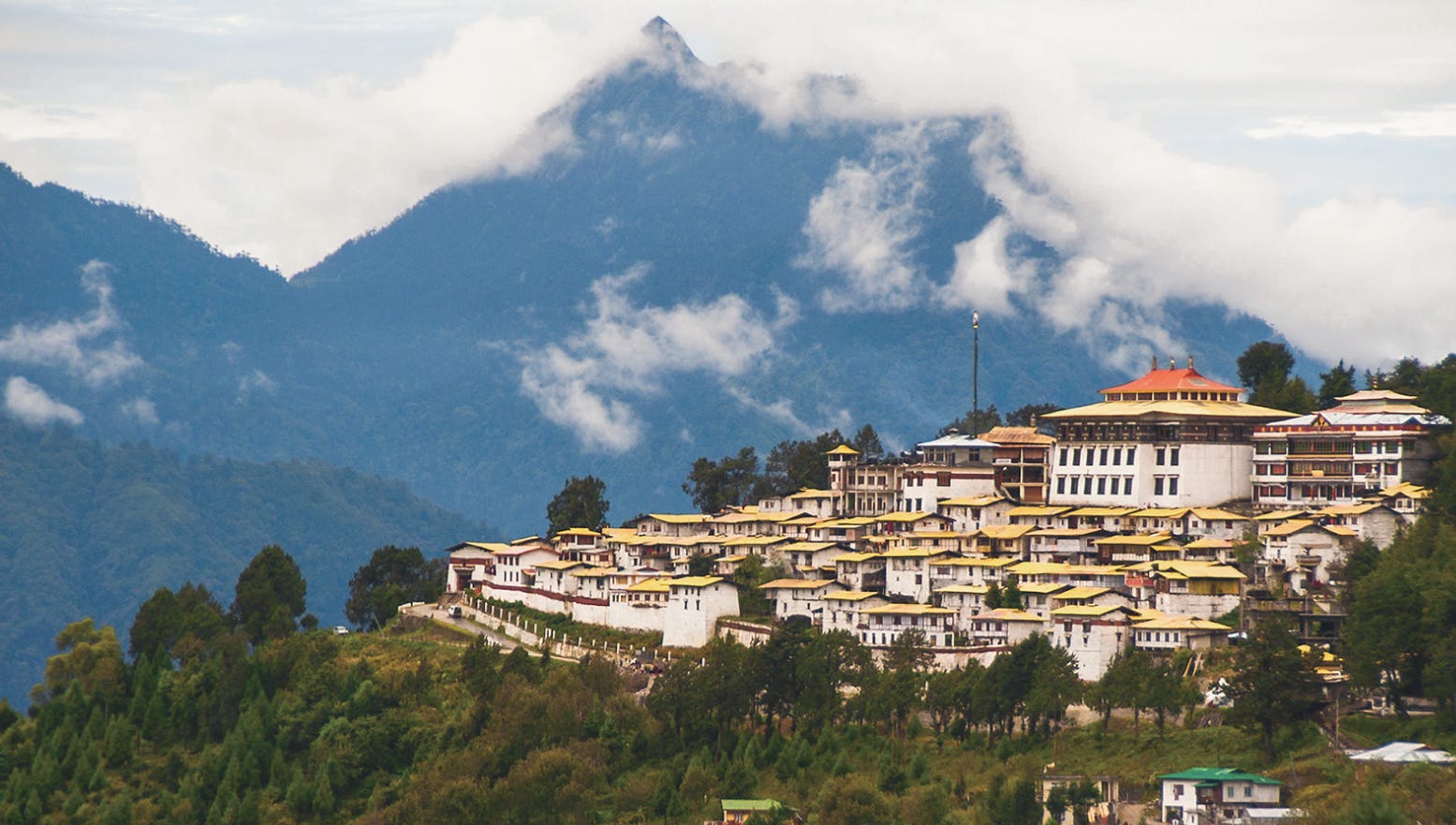
This poetic legend is rooted in Tawang (达旺), the rugged home of Tsangyang Gyatso. Tawang lies on the steep forested slopes south of the Himalayas, a realm of misty mountains and prayer flags. Culturally and ethnically, it is part of the Tibetan Buddhist world. Dominating the Tawang valley is the magnificent Tawang Monastery, founded in 1681 at the behest of the Fifth Dalai Lama. It is one of the largest Buddhist monasteries outside Lhasa and a revered center of the Monpa (门巴, a Tibetan-speaking Buddhist ethnic group native to the Tawang Region) people’s spiritual life.
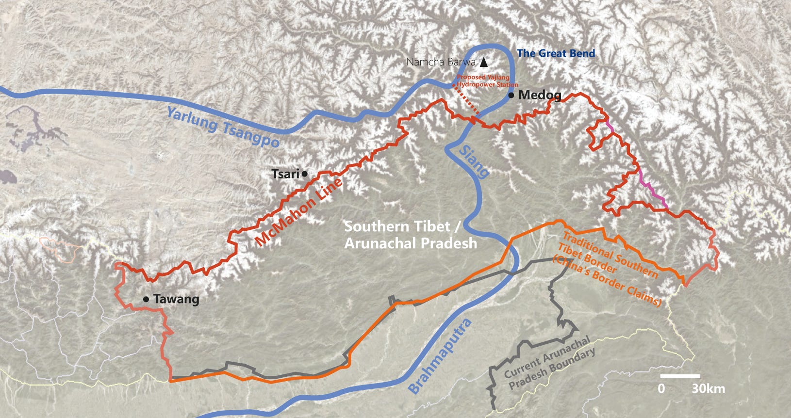
Drawing the McMahon Line
If history had taken a different turn, Tawang might still be part of Tibet today. But in the early 20th century, as empires schemed over the Himalayas, Tawang and the surrounding highlands became bargaining chips. In 1914, British colonial officials drew the McMahon Line, a boundary separating British India from Tibet. The line was negotiated at the Simla Conference between Britain and Tibet (with a Chinese delegate present but not signing), at a moment when China – convulsed by the fall of the Qing dynasty and the 1911 revolution – had little say. By the Simla accord, Tibet ceded several hundred square miles of territory, including Tawang, to British India. The Tibetan representatives agreed contingently – their acceptance was predicated on China’s agreement to the overall Simla Convention, which never came. Thus, Tibet later viewed the McMahon Line as invalid once China rejected it.
For two decades, the British themselves showed scant interest in enforcing the new border. Well into the 1930s, Tawang remained effectively under Tibetan governance. A British botanist wandering into Tawang in 1935 was detained by Tibetan authorities – a telling sign that Lhasa still administered the area. Only in 1944, with World War II raging and fears of Japanese encroachment, did British India belatedly send troops to assert control south of the Himalayan crest. They evicted Tibetan officials south of the Sela Pass, but notably did not expel them from Tawang town itself, which lay north of that pass. It was newly independent India, in 1951, that finally sent officials to formally take over Tawang, removing the last vestiges of Lhasa’s rule – an action reportedly welcomed by some locals as liberation from an “oppressive feudal regime,” according to Indian sources.
The McMahon Line’s creators had more than imperial greed at play – they also had a geographic strategy. Surveying the labyrinthine ridges and river gorges of the eastern Himalayas, British planners wanted a buffer zone shielding the Assam plains from any incursion through Tibet. Unlike Nepal, Bhutan, or Sikkim – which were distinct Himalayan kingdoms or states – the area the British termed the “North-East Frontier” (today’s Arunachal Pradesh) had no unified polity of its own. It was a mosaic of tribes and monastic districts loosely linked to Tibet. The Monpa highlanders of Tawang and Monyul (门隅, meaning the Monpa’s region, the traditional name for Tawang and surrounding areas) paid taxes to Lhasa, while further east, tribes of Lohba (珞巴, meaning ‘Southern people’ in Tibetan, one of China’s smallest officially recognized ethnic minorities, inhabit southeastern Tibet near the Indian border and maintain distinct animist traditions, oral languages, and a history of tribal autonomy shaped by the dense forests and rugged terrain of the eastern Himalayas), like the Adi (阿迪人), Naga (那加), and Mishmi (义都米什米人) lived in autonomous villages beyond any state’s direct control.
The British saw these tribal highlands as terra incognita that could be absorbed to round out India’s borders. They therefore drew the McMahon Line largely along the Himalayan watershed – the highest ridges – but with a few telling deviations. To avoid cutting of the polilgrimage trail with the new boundary, British adjusted the line to keep sacred mountain within Tibet. One example was the Tsari region, home to the holy mountain Dakpa Sheri and a 12-year pilgrimage trail. The line skirted below the key frontier village of Migyitün, so that the annual Tsari pilgrimage route would remain on the Tibetan side. In effect, British India’s border deliberately stopped short of the holy mountain and its immediate valleys, partly acknowledging Tibet’s cultural claims. Even so, once the McMahon Line was inked, it placed vast Tibetan cultural areas – from Tawang in the west to Walong (瓦弄) in the east – on India’s maps.
A Land of Dense Forests and Isolated Tribes
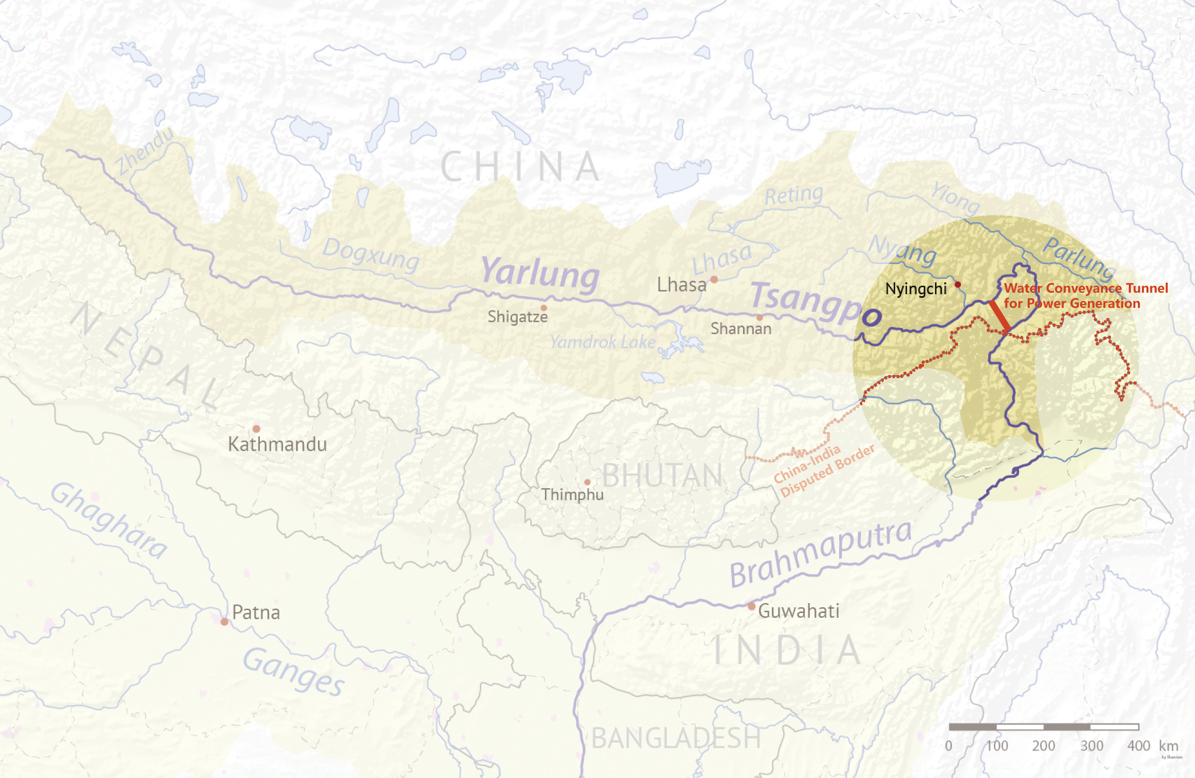
The highlands south of the Himalaya crest – today’s Arunachal Pradesh or “South Tibet” in Chinese parlance – are a study in dramatic geography. Soaring peaks give way to deep valleys where the climate transitions from alpine chill to humid sub-tropics within a few miles. The most fateful river is the Yarlung Tsangpo, which flows from west to east across the Tibetan Plateau and then takes a spectacular U-turn at the eastern end of the Himalayas. This Great Bend cleaves through the mountains in the Yarlung Tsangpo Grand Canyon, the deepest gorge on earth, twice as deep as America’s Grand Canyon. At the bend, the river plunges from ~2,900 meters elevation down to about 1,500 meters over only 240 km, as it loops around the 7,782-meter Namcha Barwa (南伽巴瓦) massif. Once across the border, the river emerges in India as the Siang – and later joins other tributaries to form the mighty Brahmaputra that nourishes India’s Assam plain. The isolation of these gorge and jungle lands preserved them as a time capsule of Tibetan and tribal life. Early 20th-century explorers described “vast and impenetrable forests” blanketing the hills, with occasional hamlets along riverbanks.
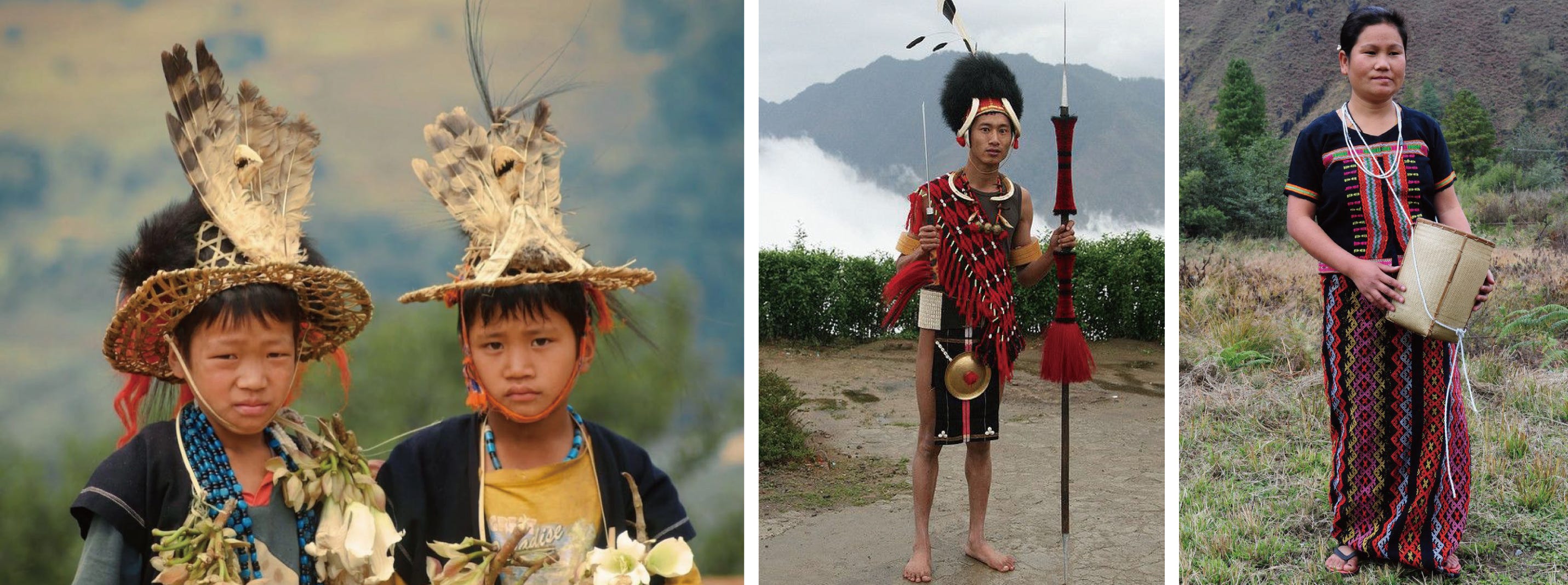
The Monpa and other Tibeto-Burman tribes (including Lohba, a diverse group of ethnolinguistic communities spread across the eastern Himalayas, share ancestral roots in the Tibeto-Burman language family and exhibit a rich mosaic of traditions, ranging from Tibetan Buddhism to indigenous animist beliefs) practiced subsistence farming and bartered with Tibetan traders who came through high mountain passes. The inhospitable terrain prevented any local kingdom from unifying the region: unlike neighboring Bhutan or Sikkim, which coalesced around valleys and trade routes, “Southern Tibet” remained a frontier of clans, each valley relatively insular. It fell under the nominal influence of greater powers – Tibet from the north, British India from the south – but developed few urban centers or roads of its own. Even today, Arunachal Pradesh is India’s least densely populated state, with just 17 people per square kilometer amid its 83,000 sq. km of mountains.
Culturally, however, the Tibetan imprint is unmistakable in much of the region. The Monpa people of Tawang and West Kameng district share the Tibetan language family and Buddhist faith. Across the McMahon Line to the south, the entire arc of the Himalayas – from Ladakh in the west through Nepal, Bhutan, Sikkim, and Arunachal – can be seen as a continuum of Tibetan Buddhist and related cultures. Yet political fate splintered this continuum: some parts became independent kingdoms or protectorates under British suzerainty (as in Bhutan and Sikkim), while others like Tawang were absorbed into larger nations. The result today is that villages sharing the same cultural heritage ended up in different countries – one valley in China, the next in India or Bhutan – with international borders slicing through pilgrimage routes and trade paths that once were united.
The 1962 War: “Forward Policy” and Fatal Mistake
When the People’s Republic of China asserted control over Tibet in 1950, the long-dormant dispute over the McMahon Line roared back to life. Through the 1950s, India administered its North-East Frontier Agency (NEFA, as Arunachal was then known) in a light-footed way, but by the end of the decade, tensions with China spiked. India’s “Forward Policy” of establishing outposts in disputed frontier areas provoked Beijing, which viewed it as encroachment on Chinese territory in both the eastern sector (NEFA) and the western sector (Aksai Chin). In October 1962, as the world was focused on the Cuban Missile Crisis, China struck. Chairman Mao’s government astutely chose this moment of superpower distraction – “the height of the Cuban missile crisis” – to launch a sudden offensive across the Himalayas. On October 20, 1962, the People’s Liberation Army (PLA) poured over mountain passes, swiftly overwhelming Indian border posts. In NEFA, Chinese troops surged southward, routing ill-prepared Indian forces and even threatening the Assam plains. By early November, the PLA had captured Tawang and advanced nearly to the foothills; the road to India’s tea-rich Brahmaputra valley lay open.
Then, just as abruptly, China stopped. On November 21, 1962, Beijing declared a unilateral ceasefire and announced it would withdraw behind the McMahon Line, relinquishing nearly all the territory it had seized in NEFA (though it retained control of the disputed Aksai Chin region in the west).
Several factors influenced this decision. The Cuban missile standoff had ended more quickly than expected, freeing the United States to potentially aid India; indeed, President Kennedy had dispatched an aircraft carrier to the Bay of Bengal in a show of support. There were also cold logistical calculations: the PLA had shown its bravery in mountain warfare, but holding NEFA would have meant trying to supply thousands of troops across the towering Himalayas – an overextended position with winter looming. The short war cast a long shadow over Sino-Indian relations: the frontier from Ladakh to Arunachal Pradesh remains disputed to this day.
From NEFA to “Land of the Dawn-Lit Mountains”
In the aftermath of 1962, India took steps to cement its authority over the area – not only militarily but also symbolically. The North-East Frontier Agency was no longer an obscure frontier; it was the scene of national martyrdom. To integrate it, New Delhi moved to give NEFA a more Indian identity. In 1972, NEFA was rechristened “Arunachal Pradesh”, a Sanskrit-derived name meaning “Province of the Dawn-Lit Mountains”.
Arunachal is an evocative moniker referencing how the first rays of sunlight in India hit these eastern peaks – a poetic name with no roots in any local tribal language, but rather in the pan-Indian tradition. The choice of a Sanskrit name was a declaration of sovereignty: this land may have been administered by Lhasa in the past, but now it was firmly within the Indian Union, complete with an Indian name. In 1987 Arunachal Pradesh was made a full-fledged state of India, underscoring that it was as much a part of the republic as any other state. Its capital, Itanagar, was built up (named after a historic Ahom fort, another nod to Indian – in this case Assamese – heritage).
India also worked to improve infrastructure in this once-neglected region. Over the decades, strategic highways like the Trans-Arunachal Highway have inched through the mountains, and small airports and helipads have been constructed to supply border towns. Still, progress is slow – the state remains remote and underdeveloped, with difficult terrain hampering connectivity. New Delhi’s efforts at “Indianization” included encouraging migration of plainspeople to the region (though on a limited scale), setting up schools and administrative centers staffed largely by outsiders, and stationing tens of thousands of Army troops and Indo-Tibetan Border Police in the state. Over time, Hindi and Assamese languages made inroads as lingua franca in some areas, and many local youth went to universities in mainland India. Yet Arunachal’s indigenous peoples – from the Monpa in the west to the Mishmi in the east – have striven to maintain their own languages and customs. Today Arunachal’s population of 1.38 million is a tapestry of over 20 major tribes, each with its tongue and traditions.
Margins of Two Worlds
Despite India’s nation-building, life for Arunachalis has often been that of a people on the periphery. In mainland India’s bustling metropolises, people from the northeastern states – including Arunachal – frequently face discrimination and racism due to their East Asian features and different culture. In 2014, a shocking incident brought this to national attention: Nido Taniam, a student from Arunachal Pradesh, was beaten to death in New Delhi after a dispute in which locals mocked his appearance. Such experiences of othering – being seen as not “truly” Indian by some in the heartland – have left many young Arunachalis in an identity bind.
China continues to claim Arunachal Pradesh as 'South Tibet' and refuses to recognize Indian sovereignty over the region, to the extent that residents of Arunachal are denied standard visas to visit China. In 2023, for example, Indian athletes from Arunachal were given only stapled visas (travel documents loosely attached to a passport rather than stamped directly into it) for an international competition in China – leading India’s sports minister to cancel his trip in protest. Every such incident underscores Arunachal’s strange predicament: its people can be made to feel unwelcome both in the country that governs them and in the country that claims their land.
Largest Hydropower Project in the world
Recently in 2025, China announced the start of construction on a $170 billion hydropower project on the Yarlung Tsangpo – a gargantuan dam that, when completed, will be the world’s largest. This megaproject, often touted as a 'project of the century,' involves the construction of a series of five cascade dams in the Tsangpo’s Great Bend, along with a massive water conveyance tunnel drilled over 40 kilometers through the mountains, where the river’s steep drop offers immense hydropower potential. The planned output is 300 billion kilowatt-hours annually – roughly equal to the electricity consumption of the entire United Kingdom. The scale dwarfs even China’s current record-holder, the Three Gorges Dam. To execute it, Chinese government has created a new state-owned company, the China Yajiang Group, signaling the strategic importance of tapping the “Asian Amazon” that flows off the Tibetan Plateau.
The lowest dam in the cascade is planned for Metog (Motuo) County, Tibet — presumably near Xirang Village (希让村) — located just next to the Indian border in Arunachal Pradesh. Designed as a run-of-the-river project, the dam will have no large reservoir or water diversion, reflecting what Chinese officials describe as 'no intention of harming' downstream interests. Indeed, the Brahmaputra (downstream of the Yarlung Tsangpo) receives the majority of its volume from rainfall within India and Bangladesh — with over 70% of its flow occurring after the river enters Indian territory — suggesting that even a massive Tibetan dam may not significantly reduce water availability under normal conditions.
India has already constructed several hydropower projects on the Siang (Brahmaputra) and its tributaries—most notably the 2,000 MW Lower Subansiri dam, the 405 MW Ranganadi project, and multiple run-of-river schemes such as Kameng, Pare, Khandong, and Heo. It makes China a relative latecomer in harnessing the river’s hydropower potential. India is also planning an 11–11.5 GW Upper Siang storage-based project in Arunachal Pradesh, which—if realized—would be part of a strategic response to Chinese upstream developments.
China has been accelerating its “xiaokang border villages” initiative — building permanent civilian settlements in frontier counties like Zayul and Medog. One village, Luowa, lies just kilometers from the McMahon Line in an area disputed by India. The visit of China’s state-recognized Panchen Lama to the village in 2022 highlighted Beijing’s symbolic integration of religion and border policy. While India sees these moves as attempts to assert control over contested areas, Beijing frames them as part of national rural revitalization and infrastructure development in Tibet. Both countries, in effect, are engaging in parallel strategies of frontier consolidation — one with fiber optics and faith, the other with railroads and roadways — leaving the political border unresolved, but physically reinforced on both sides.
The Road Ahead: Conflict or Coexistence?
As China and India entrench their positions – literally, with dams and villages – the prospect of resolving the underlying border dispute appears remote. Sporadic skirmishes still erupt, although thankfully without gunfire (both sides have observed a protocol of no shooting since 1975). From Beijing’s view, ceding claim to Arunachal (South Tibet) would be abandoning territory “historically part of China” – an impossible sell domestically, especially under current assertive vision of China. From New Delhi’s view, trading or losing Arunachal is unthinkable – not only because 1.4 million Indians live there, but also because it would mean relinquishing the legacy of the McMahon Line and admitting defeat to China’s force.
Yet, outright war is equally undesirable. Both countries are nuclear-armed. A conflict in Arunachal would likely be larger and costlier than the localized 1962 war, given India’s bolstered defenses and China’s improved logistical reach into Tibet. The Yarlung Tsangpo dam, for all the alarm it causes, might ironically force a measure of cooperation. China has so far agreed to share hydrological data during flood season with India, and perhaps as the dam project proceeds, Beijing might extend some confidence-building measures – for instance, inviting Indian experts to observe the dam’s operations or setting up a joint communication channel for water releases.
For the people of Arunachal/South Tibet, the future will be shaped by how these giant neighbors choose to handle their rivalry. Optimists envision that perhaps economics and climate realities will push India and China to a modus vivendi: China’s dam could eventually supply power to the whole region (if India were ever willing to buy electricity from it), and carefully managed water release could even help modulate Brahmaputra floods that regularly afflict Assam. There is precedent – India and China have cooperated on lesser rivers like the Siang’s tributaries, and India itself is damming many Himalayan rivers despite downstream Bangladesh’s concerns. Pessimists, however, fear a different scenario: that Arunachal Pradesh could become a flashpoint in a broader confrontation, especially if Chinese internal politics or an incident (like an Arunachali visit by the Dalai Lama or a major border skirmish) inflames nationalism.
One wild card is the Tibetan question. The current Dalai Lama (the 14th spiritual leader, lived in exile in India since fleeing Tibet in 1959) is in his late 80s. Upon his passing, Tibetans will search for his reincarnation. Many in the Tibetan exile community whisper that it would be poetic justice if the 15th Dalai Lama were “found” in Tawang – the birthplace of the 6th Dalai Lama and a place outside Beijing’s reach. Were that to happen, China would almost certainly double down on its claim and pressure India aggressively. It could take the Arunachal dispute to a fever pitch, intertwining it with the volatile issue of Tibetan succession. India, which has so far treated the Dalai Lama’s presence on its soil with careful respect for China’s sensitivities, might then have to choose between pleasing Beijing and upholding the traditions of its Tibetan guests.
In the meantime, life in Tawang and the rest of Arunachal moves at a different pace than the halls of power in Beijing and New Delhi. Monpa farmers tend to their yak herds and mountain crops; Tibetan monks at Tawang Monastery chant prayers as they have for 340 years; Adi and Mishmi villagers in the eastern forests practice animist rituals in sacred groves; Indian soldiers haul supplies up misty ranges to man freezing outposts on the LAC; Chinese workers on the other side blast tunnels for new highways along the canyon. It is a region of astonishing natural beauty and cultural richness – a place that, if it were not for the accidents of history, might have been simply a crossroads of Himalayan peoples trading and pilgriming as they did for centuries.
Southern Tibet or Arunachal Pradesh – whatever one calls it – encapsulates the drama of Asia’s past and future. It is the land of the Sixth Dalai Lama’s birth, where a lover’s poem can become a geopolitical metaphor. It is where an imperial line drawn on a map a century ago still dictates the fate of peoples. And it is where two rising powers face off in the shadow of the world’s highest peaks, each trying to ensure that they do not betray their own interests – yet somehow do not betray the peace. In the delicate balance of “not betraying the Buddha and not betraying the beloved,” one might find a hint of how both India and China could approach this contested region: with wisdom and compassion, seeing that the true interest lies not in dominion or one-upmanship, but in the well-being of those who call this majestic frontier home.
If my insights brought you a fresh perspective, please consider supporting me by buying me a coffee. Your generosity fuels my writing.
Thanks for replying. I will keep a lookout for more stories featuring border people. Or if you have them somewhere, send me the link. I used to travel in China a fair bit in the early 2000s. One of my friend those days was a Kazakh person from the very north of Xinjiang. I loved talking to her as she had stories about always trying to fit herself into different identities. https://smallthingsmostly.me/tibetan-tea-and-nur-china
I stumbled on this post by accident and it was a good read. I recently met a Lisu girl and we were discussing how their people are divided across China, India and Burma, close to where the borders meet.
Interestingly Arunachal people are perhaps the least antagonist of India of all the states in that region. Recently, I read about an Arunachal person who made a statement in support of learning Hindi as a non native speaker, and invited some critisicm from people in other parts of India who dislike language imposition.